


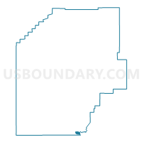
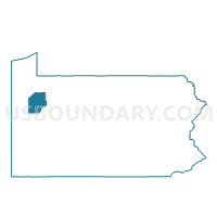
EMLENTON Voting District, Venango County, Pennsylvania
About
Outline

Summary
| Unique Area Identifier | 664071 |
| Name | EMLENTON Voting District |
| County | Venango County |
| State | Pennsylvania |
| Area (square miles) | 0.48 |
| Land Area (square miles) | 0.48 |
| Water Area (square miles) | 0.00 |
| % of Land Area | 100.00 |
| % of Water Area | 0.00 |
| Latitude of the Internal Point | 41.18033420 |
| Longtitude of the Internal Point | -79.70933800 |
Maps

Graphs
Select a template below for downloading or customizing gragh for EMLENTON Voting District, Venango County, Pennsylvania


Neighbors
Neighoring Voting District (by Name) Neighboring Voting District on the Map
- RICHLAND TWP Voting District, Clarion County, PA
- RICHLAND TWP Voting District, Venango County, PA
- SCRUBGRASS TWP Voting District, Venango County, PA
Top 10 Neighboring County Subdivision (by Population) Neighboring County Subdivision on the Map
- Richland township, Venango County, PA (777)
- Scrubgrass township, Venango County, PA (751)
- Emlenton borough, Venango County, PA (617)
- Richland township, Clarion County, PA (494)
- Emlenton borough, Clarion County, PA (8)